Tuesday, October 05, 2010

Big Bald Bird Banding Station, October 2010

Bird banding on Big Bald has been going on for 32 years. Data about migration, habitat, mating, has been collected from Big Bald and hundreds of other locations, gathered by thousands of dedicated and professional volunteers, who spend days out in the weather, usually in remote spots, without much momentary connection to the world.

The Big Bald Bird Banding Station is located along the AT, north bound from Sam's Gap, on the Tenn./N.C. state line above the Wolf Laurel Resort (http://www.bigbaldbanding.org/index.html). You have to have permission from the owners of Wolf Laurel to cross their property and then park on edge of AT right-of-way. A short hike (towards the photographer) and you come an opening where, in this case, the banding station was already in full swing by eight o'clock in the morning. It was coolish sunrise and warm afternoon. The weather along the ridge can change hourly so be prepared.

Operated entirely by volunteers who haul up the furniture, do the measuring, record an incredibly difficult data set, and make a million decisions. They're not in a locality where you can just call or look up information.

The data set includes: age, how age is determined, wing length, weight, sex, how sex is determined, ID, tail feathers, fat, and molt. (And probably more but I'm doing this from memory!). All this knowledge comes from an identification guide that is about the size of the Collegiate paperback dictionary. They have rulers, magnifying glasses, scales, water, paper bags, nets, posts, pliers, bands, records books, and what not. Just to measure one bird. We measured 120 in just one day.

The process is simple enough. An established net pattern is set up (we used 8 nets this day.) Routinely all the nets are checked for captured birds. Someone has to "pick" (the precise term for rescuing a bird from the net. Maybe un-net or de-net instead?) each, noting on a paper sack certain vital information, and then place the bird in the sack. Sounds like a game. The birds bite, claw, poop. They don't like being netted and they are only become quiet because they're too tired to resist any further.
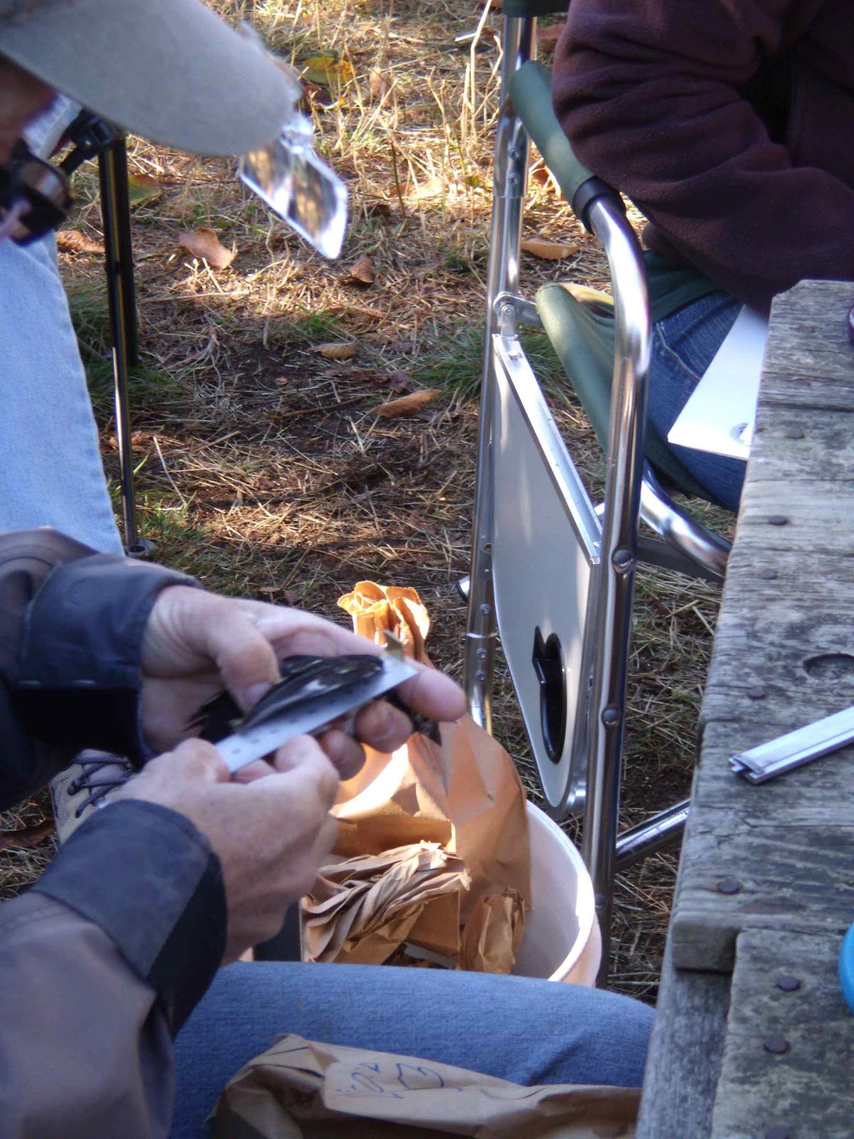
Back at the banding station, someone measures the various lengths and maturity, weight, confirms the ID, when and who's doing the measuring, and attaches an aluminum leg band. Thoroughly traumatized, the bird is released to go tell the folks where he's been for the last 25 minutes. Like their gonna believe this tale and the unlikely story about where the band came from!

Eventually all the records from all the stations make there way to a collection at Cornell University, N.Y. The tally of records so far must be in the millions.

.
Everything is carried in. If you want to eat, bring it, and take it back. All the instruments make the daily trip but the heavy tables and chairs and the like stay there over the summer (if not the winter.) I think most avid bird watchers are also outdoors people, too. We'll invest in good packs, warm clothes, good rain gear, and extras like hiking sticks, cameras, and tripods. And lug it where it has to go for those good shots and one-of-a-kind views. From our vantage you can see northerly towards Erwin, Tenn. but the southern view is mostly forest interspersed with farms, modern mountain homes, and the ubiquitous cell tower


Our day was capped off by the capture (in another net complex) of a Sharp shin hawk! There was a second net complex set up just up-trail with spring loaded nets, live bait, and a blind. Our group leader, Kathy Gunther, for the day, caught and banded a Sharp-shin hawk. This would be one of the those events you see only on Nature on PBS. He posed quietly but you only get one chance to see it hit the wing! In Kathy's left hand is a small, chip can. While working on the measurements the sharpie is tucked head first in the can to keep him under control and not only to be not feisty but to prevent an opportunistic chunk out of your hand.


Each net has it's own problems of "picking" birds. Sometimes they get themselves so tangled it'll take a second or third person to get them out. They wrap themselves in there fairly tightly, hooked around the claw, and even caught in the barbs of the tongue. The last requires gentle care and the job is done bare-handed meaning poop and cold and sensitivity all come into play. Gloves are forbidden as they dull the tactile senses. And the bigger the bird (bluejay, towhee, robin) the larger the beak and the larger the "ouch" factor. In this photo it didn't take all three to pick the towhee. But, notice, the net is invisible in the photo. The brown-green-brown striping off to the left is the run of the net and the net itself is over the green stripe.  ###

Labels: , ,

Sunday, September 19, 2010

On the Trail, again, northbound from Watauga Dam Road

One of the nicest things about the southbound hike is it becomes a morning or afternoon getaway into the woods. Any time of the year, just about, I can drive up to the trail head (half-hour's drive from my house) hike out to the shelter (one to one-and-a-half hours at the most--one way), then back. Maybe on the outside three hours of the day. I (and you) can do this in the evenings after work. And reach a specific terminal. And, the trail doesn't change elevation (much. Mostly from the road to the top of the dam is the hard part.). From the top the dam to lake shore if you go the entire three or four miles to the other side of the lake. This is one of those rare places where the trail is road level.

The northbound route from Watauga Dam road to the Vandeventer shelter is the norm. It starts straight up from the road, keeps going straight up, and doesn't level off until 4.5 to 5.0 miles. I have started this hike five times in my life and completed it only twice. I have walked south from Vendeventer having done the 13-mile leg from where Tenn. 91 crosses the trail at the head of Stoney Creek, where the Johnson County and Carter County lines meet.

This stretch is one of those places where you learn just how much fun hiking is!

And this section seems to go on forever. It's a slow trudge up hill without much change in the scenery. It's all trees and trail and it's not like you can stop and take sweeping panoramic view of the landscape. There is no landscape. It used to be the trail went along the ridge which really did feel like straight up. Now, it has switch backs which is a bit easier on the wind but adds to the length and drudgery.

But, you do get this beautiful filtered sunlight. In the fall and spring, warm air, air with smell of heat to it, runs up the southern slope. This time of year the butterflies come out in droves seeking that last plant to live from and this same warm updraft brings them right to you. It's easy to work of up a sweat on this section and not go far but just stopping gets you to a different looking spot than the last break (which is why it takes me so long to do this section) and something new to photograph.

Where the southbound stretch is very smooth, the northbound (all the way to Iron Mountain shelter yet another 5 miles up) is a slow foot-at-a-time elevator. It will teach you the value of packing light and wearing the right-weight boots.

But, also I found this time a place maybe only half mile in that would be a great stop in the fall to put up the hammock and just enjoy the afternoon. Might even want to think about spending the night. (Gets cell reception, too.) 
###

Labels: , ,

Monday, May 10, 2010

Double Springs Shelter May 6, 2010

The Double Springs shelter is a bit more of a hike than the Watauga Lake Shelter. The distance is only 2.5 miles one-way but has some long, boring, straight, up hills. At least the walk back is easier. Drive up Tenn 91 from Elizabethton, up through Stoney Creek, to the Johnson / Washington County line and you'll find a nice parking area ready made for hikers. You want to go north bound which is across the highway from the parking. Southbound is across the side road and comes in from behind you.

Here we are in the first weekend of May and the leaf canopy is still filling in on Cross Mountain. The sun was up, the trail bright, the birds active. Of note, were squirrel corn and May apples. We also saw bluet, showy orchis (but not yet blooming), and a few Turk's cap lily just starting to bloom.

The shelter is smaller than Watauga, Vandeventer, or Iron Mountain. Coming from the other side of the lake, it's about 2 miles from Rat Branch on US 321 on the other side of the lake to the Watauga shelter, then 2.5 miles or so on to Watauga Road, and then straight up hill 5-6 miles to Vendeventer, and  another 8 miles to Iron Mountain. From Iron Mountain it's smooth going for 5.5 miles to Tenn 91 and then on to Double Springs and US 321 again, down the hill all the way to Damascus about 20 miles from Double Springs.

We met two hikers at shelter and one came in later. We encountered a fourth on the trail. The two had been out 60 days (March 4 start) and Double Springs is about 450 miles. That's 1600 miles to go and 6 months of hiking left. Volume on a given day is not any sign good or bad business on the trail. You'll see batches and then no one.

Trail Days in Damascus, Virginia is May 14, 15, and 16, 2010. 

###

Labels: , ,

Sunday, April 04, 2010

Watauga Lake Shelter April 2010

One of my favorite hikes is follow the Appalachian Trail from the Watauga Dam Road to the Watauga Lake shelter on the end of the near the dam. If you use google maps to locate "Wilbur Lake Tennessee" you should be able to find the dam in the photo and then follow your nose across the lake but you'll end up in the trees! The hike is two miles, one way. Fairly easy. The hard part is the return hike from the dam to the parking lot. I hiked it on Friday, April 2, 2010, with Kim Stroud, who is a friend and member of the Elizabethton Bird Club, and a two-legged walking guide to flowers.

Clear sky. Light breeze. Record setting warm temperatures. It was a good day to be out on Good Friday.

The forest is still pretty sleepy. You can see a lot of green but it's vine and honeysuckle already making their way towards the sunshine. We found bloodroot, spring beauty, and toothwort blooming. The rest is just waiting for that right moment, like it will overnight, when suddenly everything is greened up. Here in Johnson City the pear trees are out like snow cones. The cherry trees are out. The grass is up. (I mowed some already.) Daffodils, periwinkle, hyacinth are all in full color. The quince bush is bright red.

Once summer gets here it is also very popular. Soon we'll have the first arrivals of the through hikers. Trails Days at Damascus can't be far behind. The distraction is from the lake. If you want your forest to be serene, quiet, perhaps tranquil, this is not the place. For holidays and weekends the lake is boat happy. Motors and loud music. If you want serenity go northbound instead. Just expect an uphill slog that'll take the wind out of you.

But this trip is nice and easy and year around fun (see other postings). If you keep going it's only about 2.5 miles to the swimming area on the far side of the lake from the dam and from there you head trudge further southbound to Roan Mountain.

Directions: Drive up from Wilbur Lake and as you pass where the AT crosses the road, ahead of you on the right maybe 50 yards is the dam access road. Keep on going to the parking lot on your left. Park there and double back to the access road and take it. You'll actually pick up the trail at the top of the hill. The AT will come to you from the right. Most importantly, remember, you are southbound on the AT. Cross the dam, stay the course. and after a while (I have no feel for distances) you cross over a creek (the only creek) and turn right, follow the trail a bit further along the creek and the shelter will be on your right. Look for the trail post marker also on your right.

Don't drink the water. Expect visitors.

Labels: , ,